Monday 15 December 2014

Goal Achieved

Monday 15 December 2014

Solo

Route: Ngaio Shops to Awarua St, up Bells Track to the Skyline. Climb to top of Mt Kaukau and back down via Simla Cres track. Return to Ngaio.

View to top of Bells Track from lower Awarua St
I've been meaning to get up Kaukau for a couple of months now, but events had continually conspired against me. Between toddler-at-home days, sickness and the awful weather we had in November, it looked like I wasn't going to manage it before Christmas.

Bells Track
The weather report for today was glowing - calm and warm. Awesome. I know from past experience that a light breeze around the suburbs means a bluster at the top of the hills, while still here is not still at the top. So after doing a chunk of our Christmas shopping in the morning, I headed off.

I opted to be a little lazy, and parked my car at Ngaio shops to save the 10 minutes walk each way. At the end of the walk I was so rediculously glad of this forethought! Whipping through Cummings Park at about 12:45, the climbing started almost immediately.
Traffic was quiet as I started up Awarua St, although there was a random surge of cars going past when I was nearly at the top. By the time I got to the top, I was incredibly glad that we had opted not to buy the house up there that we looked at the same day we saw our current place. I was also really hot, and realising that I probably could have left my jersey at home.

At the Skyline Walkway
The sign indicated half an hour to the Skyline Walkway, and 75 minutes to Mt Kaukau. It was 1pm. My friend Louisa had done a 7km loop up here and back in 1hr 45, so I thought perhaps the times were a little exaggerated.

Final climb to the top
It was a long, slow climb up the hill. I made it to the Skyline in about 17 minutes, and I thought I was pretty slow (and stopping frequently, both to admire the view, and to rest). I continued what seemed to be ever upwards towards Mt Kaukau, standing at the bottom of the final grunt to the transciever at 1:45, and making it to the top at just on 2pm.

View to Tappy
I spent a few minutes sitting underneath the viewing platform, trying to cool down a little from the heat, and watching the herd of cows that were hanging around, seeming pretty docile, but huge and seeming slightly threatening none-the-less.

I toyed with the idea of going around behind the transciever to actually bag the trig at the proper top of the hill, but decided against it in favour of getting home for a cool shower.

A quick mission down to Simla Cres (which actually seemed to take ages, and every time I looked down to where I was headed, it looked forever away), and then a whip along Khandallah Road, and I was stopping at the dairy to buy an icecream, before being back at the car just before 2:45.

So, just under 2 hours, including breaks, just under 6.5km travelled. Total climb 317m.


Thursday 13 November 2014

Hutbook Search Story

When I went to Herepai hut a couple of months ago, there was a very interesting, slightly long, story written up in the back of the hut book about a search that took place back in the 1970's in the area.
I've transcribed the photos I took of it for your reading pleasure :)
I have corrected some spelling (excluding the original poster misnaming Chamberlain Creek as Chamberland and Mangahou instead of Mangahao), but the sentence structure is the same as I could interperet.
I have no way of knowing when exactly the report was written up - and the author did not sign their name to it.

In the late 60's a scout party went missing on East Peak. The scout master separated from the other three scouts to find the route, but didn't return. The three scouts started to get very cold and decided the best thing to do would be to get lower down, so they dropped into Harris Creek (not know what side of the ridge they were on).
The next day they made it out to Mangahou dam and alerted the caretaker there. The next day a full search was mounted which involved the Police, Army, and Air Force, plus many tramping clubs members. A base was made at Bryant Farm and search headquarters was a caravan.
The army put up tents and provided hot meals for everyone. The Air Force [unsure of word] helicopter only made three flights as the wind became too strong to fly.

Three search parties got flown in to various locations. The rest (searchers) had to walk to their allotted search areas. As the search proceeded the weather progressively got worse (N.Wester). High winds on the main ridge were atrocious.

It was difficult to stand up and even breathe facing the wind. Fine gravel was picked up by the wind and thrown in your face. Also we were soaked to the skin by torrential rain. Conditions were so bad we were told to go to Dundas Hut. Half way there we were forced off the tops because we couldn't handle the wind.

We made a makeshift camp on some bench above Chamberland Creek, south of West Peak. A tent could not be pitched so we tied the tent out flat and got under it. I must say I was [pretty?] comfortable considering the conditions. The bottom of my sleeping bag got wet, but other than that, all were well apart from not being able to boil the billy.

The next morning we moved off at dawn, and headed back towards East Peak. We finally got to what we thought was Ruapai Peak and made a radio sked to base. We were told to proceed back to Putara Hut as the conditions were too dangerous to search in. When we got to about Hines, the rain stopped and the wind was still so strong it instantly dried our clothes out, which helped to warm us up. I remember I was wearing two jupara parkers and soaked through. Finally arriving at Putara Hut, the hut was full of other search parties bulging at the seams.
The next morning a radio message called the search officially off, as condition were atrocious for searching.

Some months later a party found the remains of a pack and sleeping bag in Chamberland Creek. The scout masters remains were never found. It was said much later that he had serious health issues and probably bit off more than he could handle, also endangering the other scouts in the party.
Possibly the hard right turn you make at East Peak may have been mist by then and got them into trouble??
Interestingly, underneath this account was another statement, from Phil Doole, one of the Venturer Scouts who was on the original trip:

Some clarifications to the above account:
1. The events happened in early September 1973 (40 years ago).
2. I was one of the 3 Venturer scouts with Ken Balfour. We were returning to Putara Hut from a bivy between Pukemoremore and Dome (we did not reach Dundas Hut the day before)
3. We reached Ruapae Peak (not East Peak) - confirmed by the pipe which is still on Ruapae. Hail & sleep, we couldn't confirm the route off towards Hines, Ken headed back towards East Peak. I dont recall why. We waited over an hour then had to make a decision to find shelter. We opted for the quickest descent into Harris Creek headwaters. Herepai Hut did not exist then, descent in the open over Herepai Peak did not seem like a good option at the time.
4. We bivied in the top of Harris Creek and continued out to the Mangahou River Hut and then on to the caretakers house at the dam, taking 1.5 days. The weather had cleared and at the time we had no concerns for Kens safety, thinking he would have made it out and would be looking for us (we were not due out until that day as it was a 4 day trip).
5. Finding Kens gear in Chamberlain Creek is a puzzle. Perhaps it was the Ruamahanga River, he may have come to grief in Ruapae Stream?
The 40th anniversary of what came to be known as Operation Balfour was covered in articles in the Wairarapa Times Age and Wilderness Magazine in 201, both of which are worth a read.

Monday 20 October 2014

Mums go wild


Hut #45

20-21 September 2014

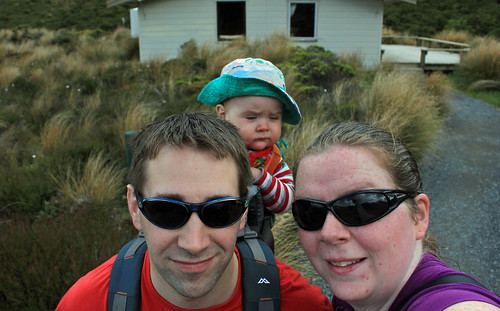
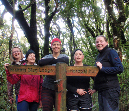
Team: Me, Sarah, Denise, Karen, Romana

Herepai Hut, Puatara Road end, Tararua Forest Park

What a weekend! I would say 4 seasons in two days, but really, it was a spring blast of winter for most of the weekend. This trip was a special one - my first overnight away without Spike. Sure, he had spent nights at Granma and Pops before, but I had not gone away overnight without him. As such, it was my first overnight tramp in just over two years, with the previous being a road end south at Blue Range while 7 weeks pregnant.

Friday afternoon there was a flurry of emails - the weather forecast for the weekend was ominous. Foul weather any which way you read it. Lovely. After one punter pulling out earlier in the week because they were unwell, another pulled out because of the weather forecast, and I was briefly concerned we were going to all decide not to go. The question was put to the chief guide and club prez as to whether perhaps we should be going - a party where every member had either not tramped in multiple years, or had only done one tramp - into the teeth of such a storm. "Dont worry", they said, "Its sheltered, a fantastic all-weather tramp".
So off we went.

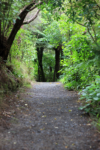
Saturday morning. It rained most of the way north, stopping literally only while we were at Mitre 10 Masterton using their bathroom and buying a biscuit or two on our way north. It started hailing as we headed north out of town, and the Putara Road was not far off starting to flood as we got nearer to the road end. The hail stopped long enough to get our packs on, and then started again as soon as we stepped onto the boggy, muddy trail.

It was a very wet walk - the track was marked by the fact it was a fast-running stream. Side-streams that would usually go unnoticed were running fast enough that some party members required assistance to get across them. As we started climbing, the hail started to settle on the ground, anywhere there wasn't running water. When we got to the top of the hill, the decision was made that there was no way we were going to try and get down the hill to Roaring Stag as originally planned - we were all too cold, and soaked through. The pouring rain and cold weather had meant no-one had stopped for a proper lunch either, we had all been surviving our slow plod up the hill with whatever snacks we had shoved in our raincoats at the van.

Hail Catcher

Plus it had now started snowing. Snow was settling on top of any flat patches of water. The ridgeline was exposed to the wind, and it bit straight through our wet gear. On we moved. The walk through to Herepai seemed to take a really long time as the weather continued to get colder (not aided by the fact I had no watch!). The snow was settling quite thickly under the trees, and was hiding traps. In one section, I stood on a submerged tree stump, and promptly slipped, landing on hands and kees in just under 10cm of icy water, with both knees landing on other submerged rocks / stumps / something. Agony.

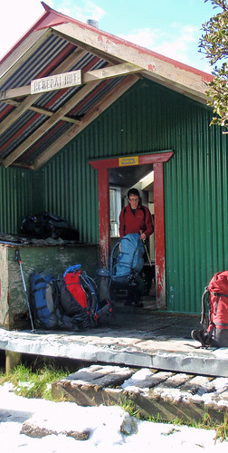
Nothing for it though - I wasn't going to sit around in the cold and cry. At some stage here I thought I saw the hut, but was mistaken. I even looked two or three times to be sure before I told Karen and Denise. But I was wrong. The smell of woodsmoke 5 minutes later was fantastic. We had arrived. The fire was going, we could get inside!

I dont know whether it was the fact we were all so cold to start with, or what, but the fire just seemed to take forever to actually do its job of warming the place up. Probably not helped by the wind driven snow on uninsulated double-metal walls (inside and out) that literally ran with condensation - absolutely nothing dried overnight, including the floor.

That said, we had an awesome time chatting with a group from the Rangitikei Tramping Club who we were sharing the hut with. They were the best kind of people to share a hut with - welcoming, friendly, inclusive. They made hot drinks for everyone, kept the fire going, told stories, shared the rest of their dinner when some of ours didn't work so well, and volunteered to clean the hut in the morning.

Sunday dawned fine. Sunshine! It had stopped snowing about an hour after we arrived at the hut Saturday night, and the difference in the track on the way down was incredible - almost no standing water, and no streams running down the hill. The barely crossable side streams were back to barely noticeable, and the river had dropped substantially. I would say we made it back to the van "dry", but given we had all put wet clothes back on before we left the hut, it would be more correct to say we didn't get rained on, although it did spit a bit as we were getting sorted to go.

Herepai Hut On our way home


A quick stop at the bakery in Kirupuni for a pie, and at Schoc for a treat, and we headed off home. It eventually turned out that my sore knee was an impact sprain. A month later and I'm still in physio, and its still tender to touch in the wrong spots. But at least I can walk again!

Hut Bagged: Herepai Hut (1 night). First visit.
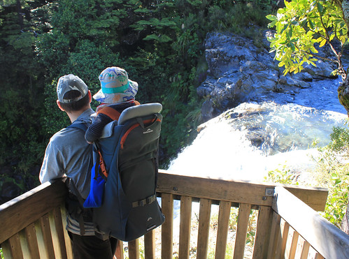
Tuesday 23 September 2014

Family "camping"

29-30 March 2014

Matiu-Somes Island, Wellington Harbour

Crew: Mark, Spike, Myself, 15 others from the WTMC Families group

Exposed Crossing

Saturday morning and we were running for the train, trying to get Spike in his carrier plus a daybag and two overnight bags from the carpark to the platform so we didn't miss the ferry to Somes Island. We made it with moments to spare, and the lovely train attendant even helped us load the bags onto the carriage.

Figuring out how we were carrying all this luggage from the train to the ferry was an entertaining game at the other end, but we got it sorted and missioned our way down the waterfront to meet with everyone else nicely in time for our pre-booked and pre-paid (thankfully) ferry across the harbour.

Our arrival at Somes Island was too early for getting in to the houses we had booked (should have checked that before arranging ferry times around Spikes nap), so we had to leave our bags at the wharf and go exploring for a while before the houses came available and we could try and get Spike to have his nap, since he was refusing to do it in the carrier.

Here Sheepy Sheepy Made it to the top

Once we eventually got into the houses and got Spike down for a sleep, it was time for a bit of chilling out, watching the weather, which was a bit average. We got a short walk of about 45 minutes in during the late afternoon before it was time to retire to the house for dinner and chilling out before it was Spikes bedtime. The entire party, who were spread over two houses for sleeping, enjoyed dinner together in the house we were established in, and the kitchens were much better equipped than I had expected.

In the house

While the bigger kids and parents wandered off on a nocturnal walk, we settled Spike to bed, and were joined back in the lounge later by the intrepid explorers, where books were read, games were played and the heat pump was thoroughly enjoyed until it was time to turn it off.

Sunday morning was a chilled affair. A quick breakfast, clean up and pack up and then off for another walk. Because we knew we had stuff on at home in the afternoon (and Spike needed his naps, which seemed to be a dominating exercise the whole weekend), we had booked an earlier ferry home than many of the others. Back to Queens Wharf, a walk back to the train station and a train home to our car and our weekend was done.

Soft cut

It was very neat staying in the houses on the island, as I have previously camped there twice. Looking back from over a year later, I do wish we had just pushed on with doing stuff rather than making ourselves slaves to Spikes naps. And I definitely intend for us all to do it again sometime.

Sunday 20 July 2014

A little different

13 July 2014

Team: Just me. (Not even me and my ipod since it died between charging and trying to use!)

City to Sea Walkway, Bolton St to Aro St section


The weather looked pretty dismal, and the report was not entertaining reading either - we were on day 2 of what promised to be at least 10 consecutive days of coll temperatures, southerly breezes and showers around the city. I had suggested to a fitness group I am in that we start doing regular walks, and the date of this one unfortunately coincided with the middle of school holidays, so a few people were away. I suspect some others were put off by the fact it was a long walk if we went the whole distance (even though there are hundreds of "jump points" along the way where public transport is right there).

Morning Light 

Anyway, 9:30am on a Sunday, I had dropped Mark to work, Spike was with his grandparents and I was standing around on Bowen St outside MBIE, waiting to see if anyone turned up, when I discovered my ipod had no battery. Stupid thing, I hadn't used it since I had charged it last the other week! A couple of minutes after scheduled departure, I went with the decision that no-one was coming and started off.

I was expecting to find this much harder than I did. I was sure last time I did any of these bits of track I found them difficult. Perhaps though, the fact of simply doing it at my pace, and not having to maintain a conversation made it easier? Perhaps it was the fact I was carrying a light pack - only a pump water bottle, my camera with its 50mm lens, 2 slices of pizza, cellphone, wallet, keys and one spare warm layer. I was never intending to go beyond Brooklyn, so I would always be within a couple of hundred metres of sustenance and shelter.

Pathway

The climb up through to the Lady Norwood Rose Garden is the usual route, nothing spectacular, but once you get up towards the metservice offices in the upper gardens, you start being sent off on trails I had never been on before. It was quite neat to be somewhere a little different. Before I knew it, I had popped out the top at the Cable Car. This seemed not only much faster, but also less steep than other paths I had taken between the two points.

Number 1

From here the track dropped down (again through some unusual zig-zagging) to the university and a trail down under Kelburn Park, around the back of the gym and into its carpark before dropping into the bush again, to appear on Salamanca Rd about 100m city side of the driveway. Climbing back up Mount St to the cemetery seemed pointless when I knew I wanted the Boyd-Wilson Field down Wai-iti St, but I did it anyway, and was astounded to discover just how large the Mount St Cemetery actually is.

Vertigo Hosing Broken Down

Seeing the new(ish) hall of residence above the field close-up was quite overpowering. It is a big, ugly building. It stands out like a sore thumb from the city, and from close up? Well, I wouldn't want that as a neighbour. Wandering down to Aro Valley was a doddle, and the cute path past the council flats was something I had never known about before.

Small and lost

Unfortunately, at Aro Park I took a wrong turn (I didn't have a map with me). The sign-post seemed to indicate turning left, so I did. But it actually meant cross the road and continue up Aro Valley a bit. So instead I got to Willis St, saw the bus go past, realised I had lost the trail and missed a half-hourly bus and decided that was enough for the day.

It took me about an hour from Bowen St to Aro St, including several stops for water, photos and route finding, and my pace was leisurely. Definitely keen to do this portion again, and include the rest of the track through to the south coast. I took a slow walk back to the car on Bowen St via the CBD, and the round-trip took just under 2 hours (including a stop at the bookstore).

Overview

Wednesday 21 May 2014

Another stupid loss

Winter tramping can be fantastic. I would imagine that winter tramping in Fiordland would be epic.

But for a group of trampers on the Milford Track this week, its turned deadly.

At the end of April, the track switches to "winter" mode. The guided walk huts are locked, the gas is turned off at the public huts, and work is started on removing several key bridges that are on avalanche paths - cheaper to chopper them in and out each season than to rebuild them every year.

One of these bridges is over the Pampolona River. Its a known flood path in heavy rain.

On the DoC website, there is a LOT of information about winter tramping in Fiordland, and especially on the Milford Track. Including this:
Many of the bridges are removed over winter to avoid damage from avalanches.
You must be competent at crossing large, swift, icy rivers.
The track over Mackinnon Pass is not marked and is often covered in deep snow.
You need to have navigation and alpine skills to traverse this section of track.
(emphasis mine)

So, I'm curious as to where this group of trampers were getting their information from about the track.  Given it sounds like they only met at the start of the track, and made poor decisions as a group, I almost wonder if all their information was from a Lonely Planet guide book.

From quotes given by a survivor, the group reached the river late in the afternoon, after a few hours hike, discovered it was high and decided against turning back because it would involve walking in the dark. A classic case of bad decision making it seems. This is why people die in rivers - because they decide to risk it. And its so horrific for the girls family, and her two tramping companions.

Thursday 17 April 2014

Tongariro Short Walks

January 2014

Based out of WTMC Ski Lodge, Whakapapa Village, Tongariro National Park

Team: Me, Mark, Spike

For some insane reason, after the success of the club families group gourmet weekend, I suggested that we should organise for the lodge to be advertised open over summer, and manned for a couple of weeks as a "drop in for wayward trampers". Which, of course, meant that I had to be there for a period of time.

After a week in Nelson, we had a long weekend at home (which included my mothers 50th birthday party) before heading up to the lodge. The weather report wasn't fantastic, but the day was glorious for our drive up - including the diversion up State Highway 4, which was a road we had never been on before.

The lodge was silent when we arrived. We were the only people scheduled to be there, quietly hoping at least someone would come join us. The space felt massive, even though we only used one bunkroom and one bathroom.

Tuesday morning, the weather was fine. Awesome. Time to get out and enjoy it. We opted to go and do a couple of short walks, to fit in around Spikes naps. We even picked things we hadn't done before.

Mounds Walk - very easy. Basically flat till a set of stairs up to the top of one of the volcanic mounds. Given you have only just started driving, or are nearly at your accomodation, I can understand why not many people bother with this one. Its interesting from a geography perspective, and you get a gorgeous view of the mountains from the top of the mound, but its also not a big deal.

Surrounded

Tawhai Falls Walk - slightly more difficult, and although it suggests its shorter than Mounds, it seemed longer. There are two down and back options to view the falls from near the top, and from all the way down in the water at the bottom. The falls are beautiful and well worth the visit, I am astounded at having never bothered with these before. How did we not know these were here? That said, there are MANY old former tracks splintering off from the main track, and I can well imagine some silly tourist ending up getting lost by trying one of them when not paying attention.

Above the falls

In the afternoon, we went exploring around the top of the Bruce. We have always driven straight up the main Bruce Road, and parked somewhere at the top or down the side, so neither of us really had any idea about the lodges on the other side of the road. We followed the 4wd track from the side of our lodge, down through past Scouts and dropped out below the top day parks, before heading up the down loop, to the cafe, and up past some of the lodges directly above the cafe before dropping on to the 4wd track again and coming home.

Up and away

Wednesday the weather was awful. Misty, almost zero visibility. We spent 95% of the day in the lodge, only venturing out to go for a swim at Tokaanu. Which was a bit of a mission with getting a 9 month old 5 minutes down to the car and back.

Two days at the carpark

Thursdays weather came and went. We had snow showers outside the lodge in the morning, then it cleared and we went for a quick walk to Meads Wall, heading home when it started hailing. The hail got heavier once we were back, and then we were treated to a gorgeous sunset.

Taranaki Window

Friday it was time to head home again. Of course, the weather had cleared. So we took advantage of it, and pushed out Spikes naps in order to take him in to Mangatepopo Hut. Parking was difficult as it was busy and we were a bit late heading in (and we had a short disagreement with an American girl about carpark reserving when there was no sign of a car). A helicopter kept buzzing overhead for track work, and it felt really odd being so disorganised and wrongly dressed (jeans and t-shirts with sneakers). We figured we were only going 20 minutes in, and were still early enough in the day that if anything happened, help would be easy to find.

Mangatepopo Hut

After a quick morning tea, it was back to the car and home via lunch in Hunterville. An awesome week, really, even if we did suffer from a bit of cabin fever with the bad weather and lack of company!

Sunday 19 January 2014

Spikes First Hut

27 December 2013

Abel Tasman Coastal Track

Team: Mark, Spike, Me

Mark and I decided to have the first part of our summer holiday (Christmas through to nearly New Years Eve) in Nelson this year, catching up with old friends of ours and their new baby, and hopefully doing some walks. We opted for a kitchen cabin at the Richmond Top 10, rather than a tent site, simply because Nelson has a reputation for getting some heavily stormy weather around Christmas, and tenting with a 9 month old in bad weather was not high on our "to do" list.

Mark had really wanted to stay at Tahunanui, as he had a strong connection to it from family holidays there as a child, but it was full up by the time we decided in July that we definitely were going away.

Various forces conspired against us, and instead of the 3 or 4 walks we had originally hoped for when we booked, we only got in one. So we made it a goodie.

Spike was up early, which for once was a blessing. Popping him in the car at exactly the time we wanted to leave for Kaiteriteri, he was asleep almost as soon as we left the campground.

Split Apple Rock

We grabbed tickets to Anchorage from the booth at the carpark, sorted sunscreen on everyone, checked we had everything and boarded our boat. Spike played with another young boy on the boat up to Anchorage, which was lovely, and helped keep him occupied. After dropping off a couple of groups at various lodges along the way, we arrived at Anchorage about 10.15am, just nicely in time to give Spike some morning tea on the deck of the hut before we headed off for a walk.

Anchorage Hut

We decided (since it was basically bang on low tide) to take the low tide track over to Torrent Bay for an early lunch before catching the 1pm water taxi back to Kaiteriteri. The climb up and over the saddle was quick, and walking through the cool water of Torrent Bay estuary was wonderful on a warm, sunny day.

Eating Sand

We had lunch on the beach, before heading back again the same way. We debated trying to find the track for Cleopatras Pool from the low-tide crossing (and therefore take a later water taxi back), but opted instead to return as planned before Spike got grumpy at being up and about for so long.

Our water taxi ran late, so we got to spend a good half an hour chilling on the beach at Anchorage, waiting. Shame we had no umbrella as there was no shade! Spike (again) didn't like the sand or the water at the beach, but was happy to be held while we stood in the water cooling off.

Unsuprisingly, he fell asleep as soon as we were back in the car. Highly successful!

Hut Bagged: Anchorage Hut, Abel Tasman Coastal Track. (0 nights). Mark / Spike first visit, Amelia 3rd or 4th (although first time at New New Anchorage Hut)

Anchorage Beach