Saturday 16 October 2010
Whakapapaiti Hut Loop, Bruce Road, Tongariro National Park
Team: John, Mark, Amelia
To be honest, the weather report for the weekend was not pleasant in outlook. Mark and I headed to the railway station weighed down with warm clothing, anticipating bad weather and a weekend spent holed up in the hut (with a possible drive to Tokaanu for the hot pools on Saturday if the weather was really bad).
The lodge was nearly empty. Our group of three plus Andrew for Saturday night, and Richards group of 4 plus a skier for Friday night. In a 32 bed lodge. You could totally tell that it was nearly the end of the winter season and the snow had been fairly average all year!
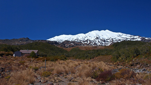
Saturday morning dawned fairly clear. There was definitely some cloud at lower levels, but up on the skifield the sun was shining. Our original plan had been to get dropped off at the Mangatepopo Road end and walk back to Whakapapa Village, where Richards group would leave the van. Discussions with people who had done that walk indicated that the track was not overly well maintained, and would be nearly impassable due to bogs after any stretch of bad weather. Which the mountain had definitely seen in the week before we arrived.
A plan was instead hatched to attack another portion of the “round-the-mountain” track, which we could clearly see from the large west-facing window of the lodge. There were two ways to get to it: The orthodox way where we either got dropped a few hundred meters down the road or walked the same, or the tramping-club way where we tried to find the most direct route to the piece of track we could see and did some exploring.
Given the walk was only meant to take about 4 hours or so (especially since we were doing it in the down-hill direction), we decided to go with the slightly more navigation-based walk. After a leisurely preparation, and having made lunch, we struck off at about 10am straight towards the Manawatu Lodge.
The walk down to the track did include some interesting moments of navigation – like when we found ourselves at the top of a bluff that we couldn’t tell the size of. Thankfully all three of us are regular trampers and comfortable with route finding, because there were times when we needed three sets of eyes hunting out an alternative path! There were only a couple of occasions when we needed to do any back-tracking, and when we did it was only a few metres at a time.
After about 45 minutes, we started finding marker poles. Some of these did not seem to mark track at all as there was nothing around them. Eventually we did find the track and we started making even better time. The track through this part was well graded, and the “steep-looking” uphill I had worried about turned out to be an easy stroll.
Once at the top, it was a fairly steep drop down into the next valley towards Whakapapaiti Hut. Arriving on the deck of the hut at just on Noon, we decided that this was definitely a great place to have lunch. Sitting in the shade, looking out and up to Ruapehu, I cant think of anywhere better to be on a sunny day. We took a leisurely lunch break of about 45 minutes before heading off down the valley further to complete our walk.
The track between the hut and Whakapapa village is a little odd.
For example:
- There is a major river that needs to be crossed. In one location this requires actually entering the river in order to cross. Further downstream, a bridge is provided
- There are areas where the track is exceedingly well maintained – boardwalks and all – and then within moments, you can be in an area where it looks like no track maintenance has ever occurred.
- Some of the signs are obviously fairly new – the well-recognised DoC-style green and yellow signs. Others are really old.
Overall, it is not an overly difficult piece of track. The river crossing could be tough on people who aren’t confident with it, or if the weather has been bad and the river is up. In cold or snowy conditions, or with strong winds, I wouldn’t do the walk. It is very exposed, and if already cold, the river crossing is still 2 hours from the road. In fact, in winter, I would be keen to go to the hut, but from the upper access only I think. It is well poled for the snow it obviously receives on a regular basis, although some of those poles were falling over a bit – we made sure we straightened and firmed up the support on any we could while there.
Eventually, through the heat, I ran out of water. It was a swelteringly hot day on the mountain. Worse, once we got down to the lower parts of the track nearer the village, the breeze disappeared. And I had brought no t-shirt or similar, so was stuck wearing a superfine merino top that is designed for keeping warm!
Needless to say, we were all glad to see the road end and the camp store selling ice-creams. Once we had stopped here to eat them, it was time to wander down to the Tama Lakes carpark to pick up the club van and return ourselves to the lodge for some relaxing and dinner.
The sun was streaming into the lodge when we arrived home, and after a relaxing (and long by lodge standards – but there was no one else wanting one, and heaps of water in the tanks) shower, it was great to sit in the lounge in the warmth and read a book to relax before dinner. It was only when I went out to the bunkrooms for something that I realised just how warm the lounge really was. And it took stepping outside for sunset photos to realise that opening the windows to cool the lounge off would be a really bad idea (it was freezing. The wind we had been expecting all day had arrived and it was bitterly cold!).
After an early night (by lodge standards at least) of about 9pm, we woke Sunday morning to clag. At times the clag was so thick we could barely see the neighbouring lodge. Needless to say, the radio stations were reporting that the mountain was closed due to combined poor visibility and wind. We spend the morning fluffing about, relaxing and reading books before cleaning up, grabbing some lunch and heading off around the mountain to the Desert Road to collect Richards tramping group, who had taken half the DoC suggested time to get out from their overnight accommodation at Otarere Hut and so had been waiting in the rain for us for an hour.
Then it was time to head home, via a stop in Taihape for coffee and another in Bulls for Dutch Licorice.
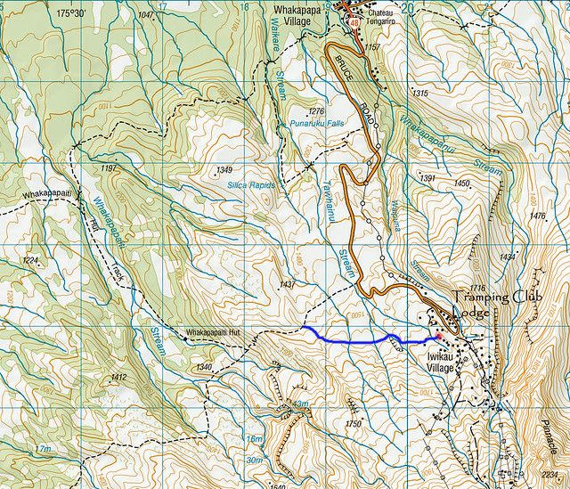
The red dot is roughly where the club lodge is based.
The blue line is a rough guess as to where our navigation took us before joining the track and heading to Whakapapaiti Hut and the Whakapapa Village
The red dot is roughly where the club lodge is based.
The blue line is a rough guess as to where our navigation took us before joining the track and heading to Whakapapaiti Hut and the Whakapapa Village